The 'Britice' data source is available free of use. It gives detailed data of all glacial evidence in the landscape of the UK.
This can be used as part of a starter activity in the classroom. Begin with a photo of a local feature and ask your students 'how was this formed?', and then work up to an explanation of the last glaciation.
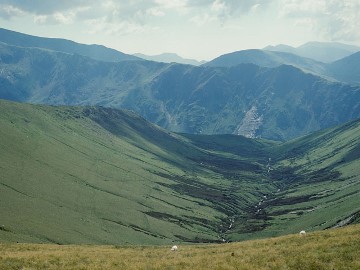
Cwm Afon Dudodyn in Snowdonia is an example of such a feature. Its U-shaped hanging valley indicates the influence of glacial action during the Pleistocene ice ages.
Kate Amis, Schools Liaison and Widening Participation Officer for the School of Geography at Queen Mary University of London, shared this idea after hearing Tris Irvine-Flynn's lectureSnowballs and mudballs: our icy planet, it's history at Day 1 of our New Teacher Subject Days course 2017/18.
Schools Programme members can download the resources from the event in the PTI Staffroom.
Want to discover more inspiring subject knowledge? See our upcoming courses and events for 2017, including upcoming CPD Day Population change: issues and challenges.
Find more knowledge nuggets here!
Image: By GP Williams, via geograph (http://www.geograph.org.uk/photo/2104544). Licensed by Creative Commons (https://creativecommons.org/licenses/by-sa/2.0/)